Drone Mapping & Surveying

Photogrammetry has never been so efficient. We’re able to deploy UAVs
anywhere in Australia (within aviation safety compliance) for professional drone mapping.

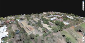
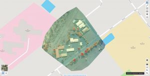
With emerging technological capabilities in aerial mapping, we can offer survey-level 3D maps and models from drone images. Save on operational costs by spending less time in the field, and ensure accuracy with detailed reports.

We use the latest drone hardware, together with the latest mapping software options such as Pix4D, DroneDeploy and Maps Made Easy.

WHY CHOOSE US?

Certified & Insured

We’re fully certified with the Civil Aviation Safety Authority of Australia, and backed by $10 Million in public liability insurance.

Fast Data Processing

In most cases, we can deliver survey reports within 3 days of the shoot.

Safe & Reliable

We’re proud to say that we’ve maintain a zero-incident record since the start of our aerial operations.

TAFE NSW – Wagga Wagga
3D Aerial Mapping

Surveying

TAFE NSW – West Wyalong
Aerial Surveying

Surveying

CONTACT US

Sydney, Australia

0413 864 515

hello@spyre.com.au

Fill out this field
Fill out this field
Fill out this field
Fill out this field